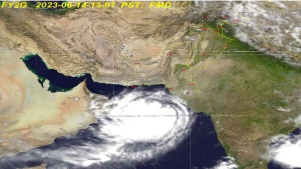
Islamabad, June 14, 2023: BIPARJOY, a very severe cyclonic storm, is projected to make landfall along the coasts of Pakistan and India on June 15. With winds reaching speeds of 100-120 km/h and gusts of up to 140 km/h, the cyclone is expected to bring significant disruptions and potential hazards to the affected regions, according to National Disaster Management Authority (NDMA).
Based on international weather forecasting models utilized by the Pakistan Meteorological Department (PMD), BIPARJOY is forecasted to follow a North-Northeastward path and cross between Keti Bandar in Southeast Sindh and the Indian Gujarat Coast during the afternoon or evening of June 15. While the precise impacts are subject to further development of the system, proactive measures are recommended to mitigate potential damages.
READ MORE: Severe Cyclonic Storm BIPARJOY Expected to Hit Pakistan and India, Alert Issued
The current forecast indicates the following possible impacts:
a. Widespread wind-dust, thunderstorms, and heavy rainfall, with extremely heavy falls, are expected in Districts Thatta, Sujawal, Badin, Tharparkar, Mirpurkhas, and Umerkot from June 14 to June 17, 2023. Squally winds with speeds ranging from 80-100 km/h and gusts up to 120 km/h are also anticipated.
b. Districts Karachi, Hyderabad, Tando Muhammad Khan, Tando Allayar, Shaheed Benazirabad, and Sanghar are likely to experience dust, thunderstorms, rain, and occasional heavy falls, accompanied by gusty winds ranging from 60-80 km/h, from June 14 to June 16, 2023.
c. In Districts Hub and Lasbella, isolated heavy falls of rain, thunderstorms, and dust are anticipated from June 14 to June 16, 2023.
d. Loose structures, kacha houses, under-construction buildings, solar panels, trees, and billboards along the coastal areas and surroundings may suffer damage due to squally and high-speed winds.
e. Along the Sindh coast, sea conditions are expected to become very rough to high, with wave heights ranging from 2-2.5 meters. Balochistan coast, particularly in Sonmiani, Hub, Kund Malir, Ormara, and adjacent regions, may experience rough to very rough sea conditions with wave heights of 2 meters.
f. There is a high risk of coastal flooding in Districts Badin and Thatta as the cyclone progresses and reaches the coastline.
g. Due to the anticipated sea conditions, fishermen in Sindh and Balochistan are advised not to venture into the open sea until June 17, 2023.
h. The coastal areas from Karachi to Indian Gujarat, specifically the landfall point in Keti Bandar and its surroundings, face a high risk of storm surges ranging from 3-3.5 meters (8-12 feet). This risk is further compounded by the occurrence of high tides twice daily.
Authorities and residents in the affected regions are urged to stay updated with the latest weather bulletins and take necessary precautions to safeguard lives and property. It is essential to heed the warnings issued by local authorities and follow evacuation protocols to ensure safety during this severe cyclonic event.
Note: The above information is based on the current forecast and may be subject to change as the cyclonic system develops further.
READ MORE: BIPARJOY Strengthens in East-central Arabian Sea, Expected to Impact Southern Sindh
